
19th-century Havre de Grace was a busy time. Hunting and fishing, farming, shipbuilding, and mills were making way for the canal, steamers, railroads, ice harvesting, and the canning industry. We hope this post will show enough of the changes to make you realize how flourishing our community has been since its beginnings.
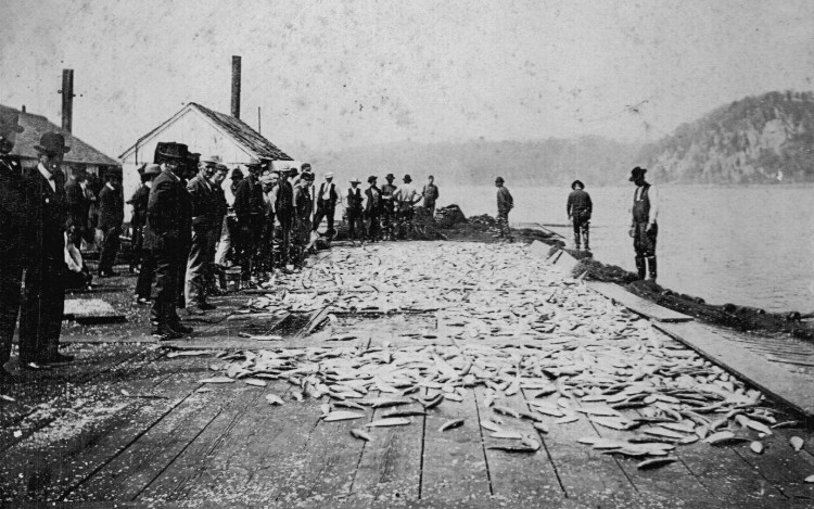
Havre de Grace, from the date of its incorporation as a town {1785}, continued to grow steadily in population and wealth. Fishing was the source of income for many of its citizens. The inns and hotels required the services of a considerable number of people. During the long, hard winters when the river froze to a depth of eighteen inches or more, many men were engaged in cutting, storing and shipping ice. There were services necessary for the farmers who made Havre de Grace their shopping center–blacksmith shops, wagon factories and repair shops, feed stores, general stores and hardware stores. Canneries were built in the city and provided an outlet for more corn and tomatoes than the farmers had been formerly disposing of, and took a considerable portion of the local fishermen’s catch. The coming of the railroad meant employment for both skilled and unskilled labor.”
from History of Havre de Grace, “The Town We Live In” by Elias W. Kidwiler, (c)1947
Susquehanna and Tidewater Canal
The 19th century saw major growth in Havre de Grace. The canal, railroad, canneries, automobiles, and more were major influences.
. . . it was not formally opened until the spring of 1840. Lumber, coal and grain from up-river points were carried by the canal to its terminus at Havre de Grace and distributed from here to various points either by rail or steamer.
The Susquehanna and Tidewater Canal, extending from Wrightsville to Havre de Grace was chartered by Pennsylvania and Maryland in 1835.
. . . The Johnstown Flood (1889)caused catastrophic loss of life and property damage there (Johnstown, PA), swept away a dam in The Susquehanna at Columbia, Pennsylvania, ending the life of The Tidewater and Susquehanna Canal except as a local waterway. The lumber and coal which had comprised the greater volume of the canal’s traffic was eliminated and from 1889 to 1900 wheat and fish were the most important cargoes that passed through Havre de Grace via the canal. It suspended operations about 1900 . . .
from History of Havre de Grace, “The Town We Live In” by Elias W. Kidwiler, (c)1947
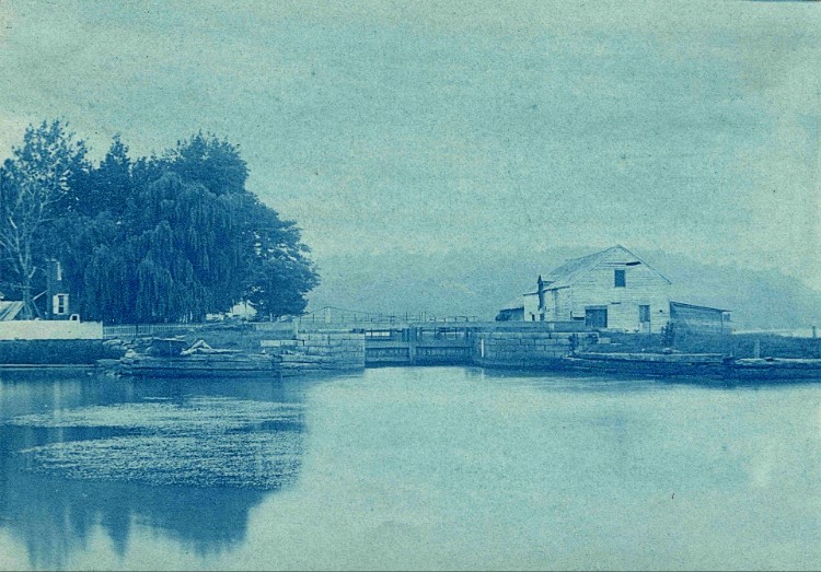
Photo courtesy of Kelly Family Album
Another commentary on the canal:
“The lock was one of several in the course of the canal which extended, in Maryland, to Wrightsville, a distance of about forty-five miles. For nearly sixty years, a stream of barges bearing coal, lumber, grain and merchandise came through Havre de Grace for reshipment to other points. In the later years, serious breaks occurred in the tow path and, due to the development of steam power, the canal was finally abandoned.”
from Historic Havre de Grace, by the Havre de Grace Public Library (c)1939
CLICK HERE to read an excellent article on the Susquehanna Museum at the Lockhouse from HdG Beacon.
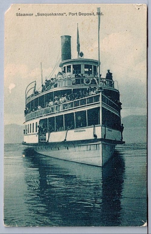
Steamers
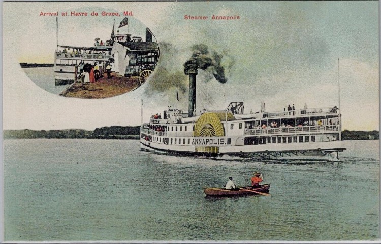
Before the rail lines began their domination of domestic transportation, however, Havre de Grace enjoyed some distinction as a waterways outlet for local products. Tobacco was raised in considerable quantities for only a comparatively few years, but during the era in which it was cultivated north of Baltimore the greater part of it passed through Havre de Grace on its way to the processors. Fish continued for many years to be the principal item of export and for ten or fifteen years lumber and coal which reached the bay at this point through the Susquehanna and Tidewater Canal was shipped by water.
The first steamboat to make regular calls at Havre de Grace was “The Canton,” in 1840. It was followed by “The Gosport,” “The Cecil,” “The Port Deposit,” “The Gypsy,” “The Ferry,” “The Rodman,” “The Isadore,” “The Alice,” “The Maggie,” “The McCall,” “The Benigna,” and “The City Belle.”. . . As the railroads began taking at the source more and more of the long distance hauling which had previously been delivered by water these bay steamboats diminished in importance and suffered such steadily decreasing revenues that there operation was no longer profitable.
from History of Havre de Grace, “The Town We Live In” by Elias W. Kidwiler, (c)1947
Railroad
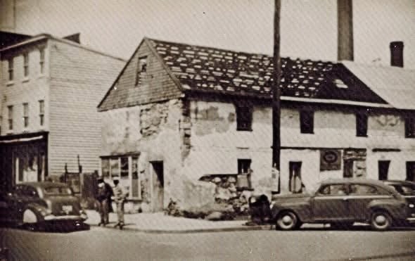
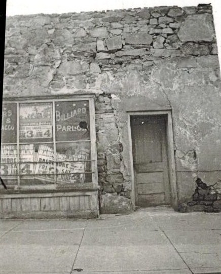
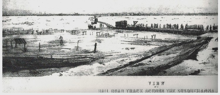
Less than twenty years after the invention of the steam locomotive [1815 by George Stephenson] a railroad was on its way to Havre de Grace. A line known as The Baltimore and Port Deposit Railroad was started from Baltimore in 1834 and in 1836 reached Havre de Grace. The original right of way is still in use by The Pennsylvania Railroad as a spur to reach the waterfront. It comes through St. Clair Street [now Pennington Ave], most of the distance below street level and reaches the waterfront just below Washington Street. For more than twenty years trains were ferried across the river from the foot of St. Clair Street to a point opposite on the Cecil County side of the river. The old stone building on the north-east corner of Washington and St. Clair Streets was the original passenger and freight station in Havre de Grace and was in service as such until 1867. (SEE PHOTOS BELOW)
. . . The ferrying time for trains was one and one-half hours, which represented a considerable delay in running time but it was for thirty years the only way trains could cross the river.
. . . On February 5, 1838 The Philadelphia, Wilmington and Baltimore Railroad of Pennsylvania, The Wilmington and Susquehanna Railroad of Delaware and The Baltimore and Port Deposit Railroad of Maryland were united into one corporation, The Philadelphia, Wilmington and Baltimore Railroad Company. At Havre de Grace a steamboat replaced the original hand operated ferry for carrying trains across the Susquehanna River. By 1852 both the passenger and freight traffic on this railroad had more than doubled and the company began investigating the possibility of bridging the Susquehanna.
. . . in the spring of 1863 construction of the bridge was started.
On November 28, 1866 the bridge which was of wooden spans was completed and placed in service. . . . The wooden spans were replaced by iron during the six year period between 1873 and 1879. A foot walk was built alongside the bridge tracks but the ferry still remained the only means of crossing the river except for trains and pedestrians.
from History of Havre de Grace, “The Town We Live In” by Elias W. Kidwiler, (c)1947
to the waterfront
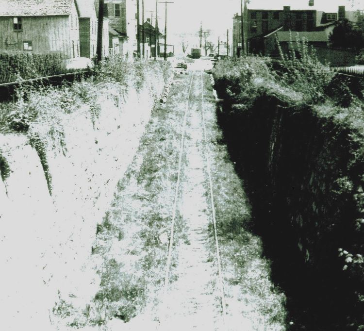
Following is an interesting statement referring to “The Cut” – the spur that came off the railroad and went down St. Clair (now Pennington) to the waterfront (past the cannery):
One of the boys who started to school in the little brick school house in 1832 was John L. Johnson. Mr. Johnson is now dead, but before he died he made the following statement to Mr. Joseph W. Chamberlaine, under date of September 12, 1908, with a request that same be published at his death:
“. . . I was born in New Castle County, near Delaware City, in the State of Delaware, March 12, 1822, was brought to Havre de Grace in 1824, where I have been living ever since. I was adopted by Capt. McCaskey, who was in the war of 1812.
When Lincoln went through Havre de Grace I was one of the forty hired by the railroad company to guard the Bush River bridge against attacks and fires. All of us were armed with navy revolvers. I was signalman on the bridge.
. . . When the St Clair Street cut was being dug out, I was in a spelling class in the school room, corner Union Avenue and St. Clair Street [now Pennington Ave] . . . when after the blast a rock weighing about a ton came crashing through the roof, but fortunately, no one was hurt.
. . . I remember the first train of cars coming to Havre de Grace. The engine was very odd looking, the boiler stood on end and the smoke stack was on top of that. The Engineer stood on an uncovered platform, and the engineer’s name was Edward Foard.”
from Historic Havre de Grace, by the Havre de Grace Public Library (c)1939
Another interesting mental picture of the bridges over “The CUT.”
The railroad was to bridge all streets and alleys to the satisfaction of the commissioners, and in 1837 a lifting draw-bridge was erected on Washington Street [we believe this should be Union Ave]. This was removed in 1839, due to its unsatisfactory operation, as we find the citizens held a public meeting to complain against being kept waiting too long for an opportunity to cross the street.
from Historic Havre de Grace, by the Havre de Grace Public Library (c)1939
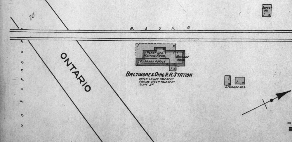
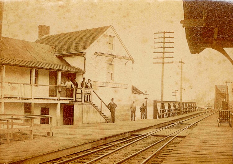
A little info regarding the railroad depots in Havre de Grace:
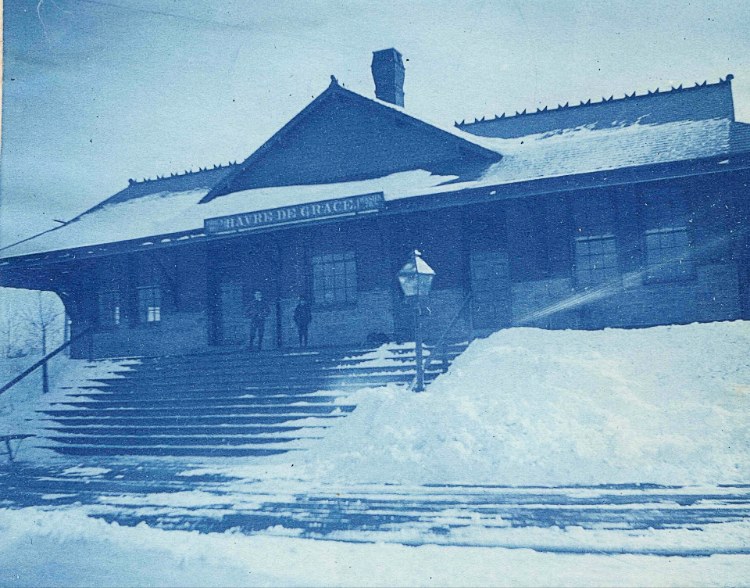
Kelly Family Album
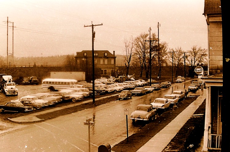
by Tire Center – 1950s
You can learn more about “The CUT” in this earlier blog post.
Farming and Canning
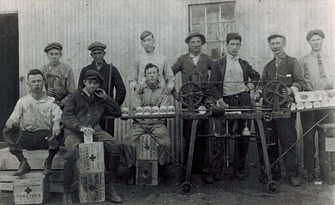
As the population of the settlements and the nearby countryside increased and as the demands for flour and corn grew greater from the cities the planting of grain was increased and farmers found a ready market.
Shortly after the Civil War the preservation of vegetables by canning was made possible and before the beginning of the twentieth century many farmers in the vicinity of Havre de Grace were devoting a large part of their acreage to the cultivation of corn and tomatoes. Even today {1947} the greater part of farm products grown in Harford County consist of these two items, although the wheat crop of the county is not a negligible item. The canning industry has continued to the present day to be a substantial part of the city’s economy and furnished employment for hundreds of people during the busier seasons.from History of Havre de Grace, “The Town We Live In” by Elias W. Kidwiler, (c)1947
The following are specific blog posts related to canning:
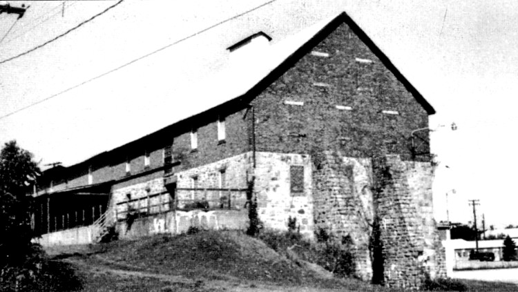
Also, a story on the SENECA CANNERY from page 10 of the Lockhouse to Lighthouse publication.
Click here – SENECA CANNERY – for history of the building from Historic Havre de Grace website
Ice Harvesting
Have you ever wondered how they kept things cold in the 1800s-1900s? We’re so used to pressing the lever on the fridge for ice water and ice cubes, or at the very least getting them from an ice cube tray in our freezer compartment.
But before refrigerators, ice was harvested in winter and stored in ice boxes in homes or businesses. It was a grueling task for man and horse. Sawing ice chunks and lifting them with tongs for delivery to the nearest ice house was an extensive operation. It’s challenging to imagine tens of thousands of tons – yes tons – of ice collected in such a manner.
Here’s an extensive post on Ice Houses in a previous blog;
An interesting addition to the time in 1852 when the river froze, and the ferries that carried railroad cars across the river couldn’t run.
“A protracted spell of exceedingly cold weather in the winter of 1852 made this [crossing the river on ferries] utterly impossible .A connection had to be made somehow, so a track was built on the ice and for nearly six weeks, or from January 15 to February 24, this track was in constant use with the exception of a day or two while it was being moved from its first position to one that was more secure. That it was felt the track wa secure is shown by the fact that the United States mail was carried across the river in that way.
Nearly all the cars were eight wheelers and were, of course, very much smaller affairs than those in use today. Not the slightest damage was done to any persons or property carried. Many venturesome souls made the trip just for the sake of the experience. In all 10,000 tons were carried across the river on the ice, and of this amount 4,000 tons were merchandise of various kinds.
from Historic Havre de Grace, by the Havre de Grace Public Library (c)1939
The Market-house
Below is a bit about a Market-house that demonstrates the thriving community. We wish we had a picture or drawing of this building.
The Market-house when finally erected, about 1840, stood in the center of Congress Avenue with its front just east of the line of the alley between Washington and Market Streets. It was seventy-five feet long and thirty feet wide. The roof was supported by twenty-six pillars of brick twenty-two inches square and eight feet high. The floor was of brick. The lower part, except at the west end, was open for market purposes, and after it ceased to be used as a market was utilized as a shed, in which to house wagons and carts. The town lock-up was in the lower part and was used as a guard room during the Civil War. The upper story contained the Council Chamber and a town school room. When the building was abandoned, the upper part was transported down town and converted into two double dwelling houses which may be seen, one on the east side of Washington street, the second house south of Girard; the other on the south side of Girard Street between Washington and Market Streets. This latter house is rather high and on the front has a porch to two stories. There was a sand bank there and when it was removed the house was underpinned and a lower story built.
from Historic Havre de Grace, by the Havre de Grace Public Library (c)1939
Not Everything was Rosy
An interesting pen picture of Havre de Grace in the year 1855, is contained in Rector Browne’s Historical Sketch of St. John’s Church, and reads as follows:
“Mr. Crompton was rector of both St. George’s and Havre de Grace, and lived at Perryman, coming up every Sunday afternoon, riding the nine miles on a pony. It was the duty of little Willie O’Neill (aged 10) to watch the old Post Road from the upper story of the tower of St. John’s, and when Mr. Crompton and the pony hove in sight, to begin ringing the bell and to continue until they reached the church. Another of his boyhood duties was to bring forth in rainy or muddy weather sundry sixteen foot boards to be duly laid across the gutters and the soft places of the street in front of the church, and after service to stow them away again. Havre de Grace was far from being the tidy town it is now. In the unpaved streets weeds grew so tall except for a narrow wagon path in the center, that a boy of ten years could not see another boy across the street. Dogs, hogs, ducks, geese, cows, goats and horses roamed where they would The place was unkempt and unhealthy, full of fever and ague.”
from Historic Havre de Grace, by the Havre de Grace Public Library (c)1939
The 19th century was a bustling time for commerce in Havre de Grace. We barely touched all that was happening. The city was growing quickly, but not without its drawbacks. Let’s see how we do in the 20th century, watch for America250 – #7.
In looking back, we pay tribute to the hardy citizens
who continued to put their shoulders to the wheel,
creating the city we enjoy today. Their perseverance,
even when half to two-thirds of the town was burned in 1813,
leaving many families homeless and destitute, was steadfast.
It’s also interesting to note that our fine city, with its amazing historic buildings, is a result of residents caring about our history over the centuries.
George, our casual historian, encourages you to visit the main blog page and scroll through the posts for more stories. You are also encouraged to stop in at Bahoukas Antique Mall and browse more than a dozen cases and a huge wall of Havre de Grace History memorabilia! Be sure to say ‘hi’ to George!
Stay tuned for our next blog post – #7 Havre de Grace – a growing city part 3.